The Challenge
NBGIF works with private landowners across multiple states to implement NRCS conservation practices, with cost-share payments based on spatial measurements, such as acres of prescribed burned habitat or linear feet hedgerow cover, adding to the matrix of habitat restored. NBGIF was building from the ground up, with no GIS of its own and no central home for project data. Projects, contracts, and payments were managed in Striven, a business platform with no spatial capability, so measurements taken by field staff, which determine payments, were disconnected from the project management system.
Our Solution
Dymaptic stood up NBGIF's first GIS environment and expanded it into a connected field-to-office system, including:
- ArcGIS Online as NBGIF's first central home for project data.
- A customized ArcGIS Field Maps application for online and offline field collection, built around a structured, nested data model (project area, treatment actions, NRCS practices) so geometry is captured once and reused rather than duplicated, with smart data-entry forms filtered by state and NRCS code and managed domains to keep records consistent and complete.
- A two-way integration between ArcGIS and Striven, NBGIF's project and contract management system, via the Striven API, paired with ArcGIS Notebooks (Python) automation that generates project records and GIS-derived quotes in Striven directly from finalized field data with no manual transcription.
- ArcGIS Experience Builder administrative tools that let NBGIF configure grant and reporting types, project templates and allowed values without developer involvement, and push projects through the integration on demand rather than waiting for a daily system-wide data share.
- Support for multiple project types and payment structures, a streamlined workflow variant and expansion to additional states, with ongoing production maintenance and enhancement.
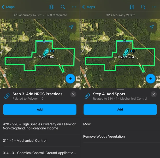
Adding NRCS practices and treatment spots to a project in ArcGIS Field Maps
The Impact
NBGIF went from no GIS to a scalable cloud platform of its own. Field measurements flow into project records and payment quotes without anyone needing to re-enter data. The system has grown with the organization, expanding to new states and new project types. In its first two years, NBGIF has recorded more than 1,100 projects, 5,000 NRCS practices and 12,000 resulting tasks.